
Roads, Common Ways and High Ways, Part III
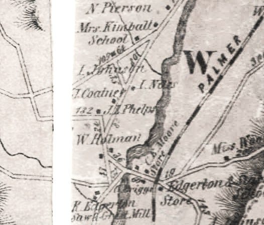
Wolcott's Road, the Willimantic River to Ashford

A Township Patent
In 1720, the Connecticut General Assembly voted to give eight men a patent for sixteen-thousand acres in the hills of eastern Connecticut, the township was named Willington, sometimes spelled phonetically as Wellington.
The sixteen thousand acres was minus a number of land grants previously awarded by the General Assembly plus a couple of existing farms owned by Ashford men. The eight owners of the patent, called the patents Proprietors, held a variety of government offices at different times. Most served as General Assembly Delegates, some serving at the time of the patent award. One was an attorney for the colony.
In 1724 one of the Proprietors died resulting in his share of the patent apparently being divided up. After the issue of the patent, with some of the land assigned, sold traded or awarded to others, ownership of parts of the sixteen thousand acres was claimed by a variety of assignees. Land speculation had descended on this fold of hills and valleys of the eastern hills.
By 1726, a ninth patent owner had been added. He was an attorney from Boston brought in to help deal with people living within the sixteen thousand acres who didn’t have legal title to the land they were living on. These people were deemed to be squatters. In one document they were referred to as transients. The patent attracted men who seemed to be inclined to living outside established Societies.
A couple of the squatters had paid someone for their land, one purchased land from the Mansfield Proprietors as early as 1713, and they later found themselves having to pay a second time for a deed from the Willington Proprietors.
Two other early settlers had set up farms and later purchased one-sixty-forth shares of the patent (roughly some 200 acres). They were considered legal Inhabitants with the ownership of their farms perhaps considered to be a fait accompli, all this predating any distribution of the patent’s lots to the nine Proprietors.
Other squatters and transients left of their own accord, some settling in nearby towns, and others apparently removing to the frontier town of Palmer MA, called Kingstown and referred to as the Elbows. A couple settled near Ware, before any Congregational Society was established.
Not all squatters were chased off A couple of early settlers, after the town’s incorporation, purchased the land they were living on prior to 1727 from the Proprietor who owned the lot where their farm was located.
By early 1727, according to land and birth records, there were about a dozen families living in Willington. These were recognized as being legal Inhabitants although some of them did not have title to the land they were living on.
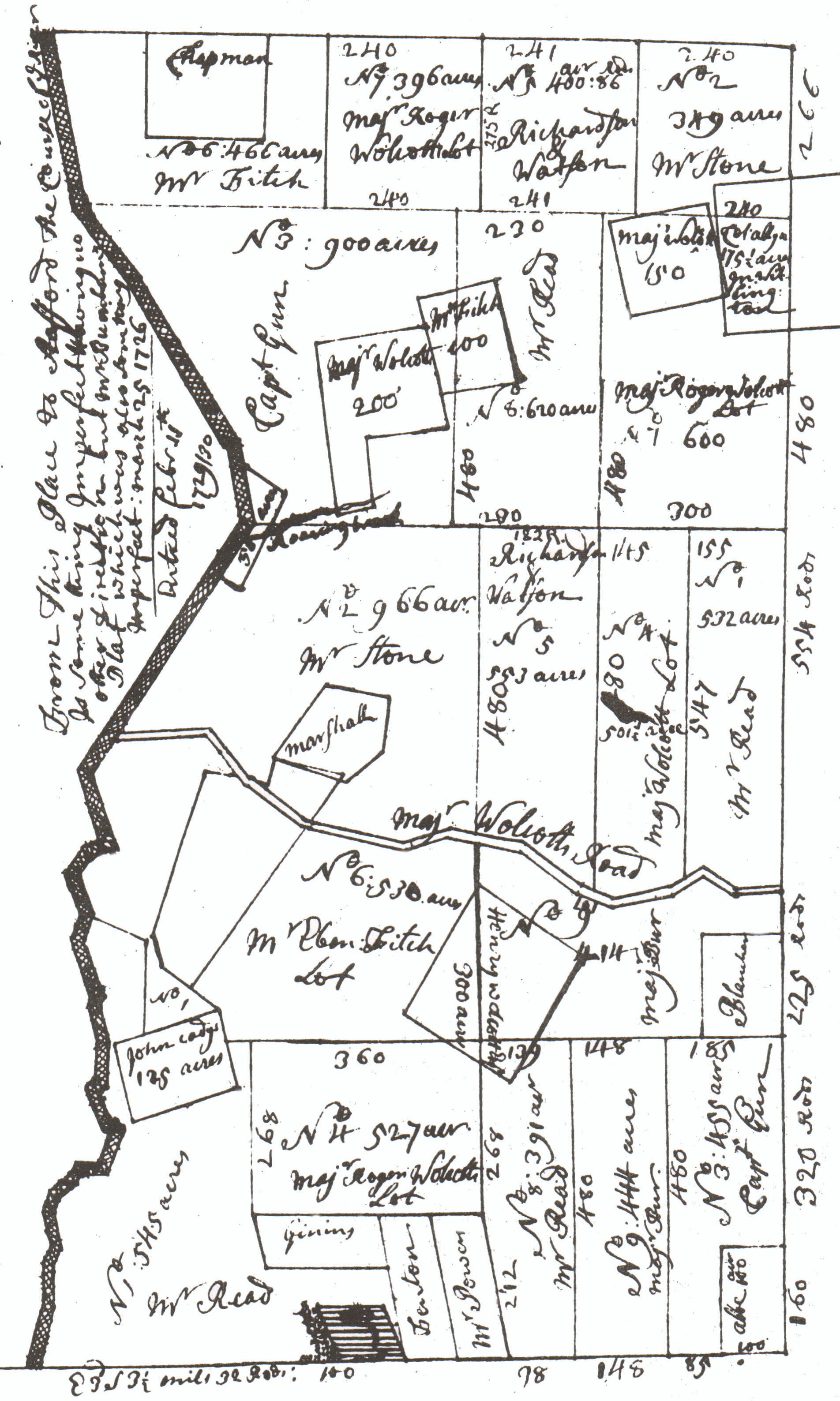
In 1726, Josiah Conant, the appointed surveyor of Windham County and a General Assembly Delegate from Mansfield, had drawn a plot of the sixteen thousand acres showing eighteen Proprietors lots. This plot was used in June 1727 to record the two lots to be awarded to each Proprietor. The lots were ostensibly laid out previously by Conant and Roger Wolcott, a delegate for Windsor, and one of the original patent owners.

On May 11, 1727, the General Assembly granted town powers to the inhabitants of Willington, thus they were incorporated into a body politic, under the governance of the Town Meeting, to be overseen by an orthodox Congregational Society once it was established and a minister appointed by a vote at a Town Meeting:
“Whereas there is a certain tract of land in this Colony, bounded south upon Mansfield, east on Ashford, north on Stafford, and west on Willamantick River, which this Assembly have ordered to be known by the name of Willington : And whereas this Assembly be well certified that there is a considerable number of inhabitants and families now dwelling on said tract of land, and that said tract of land is sufficient to make a township: Whereupon this Assembly do grant and resolve, that said tract of land shall be one entire town, and shall be known by the name of Willington, and that the same privileges of other towns in this Colony is hereby granted unto them : and the brand for the horses in said town shall be the figure [H]. And for the setting up and maintaining of the worship of God in said town, this Assembly grants a tax of eight shillings per every hundred acres of land in said town, and pro rato for other quantities, to be paid by the owners and proprietors of said land for the space of four years ; the first payment to be made at or before the last day of October next, and so annually on the last day of October till the said four year be fully expired. And this Assembly do hereby appoint Major Roger Wolcott, Esqr, and Mr. Samuel Woodbridge, clerk, a committee, together with two other who the said town shall choose, to make a rate on said proprietors and deliver it to such collector as the town shall choose to collect said tax ; and also to call said collector to account, and see that said money be disposed of to the use aforesaid. (The Public Records of the Colony of Connecticut, From May 1726 to May 1735 Inclusive. Page 111)
The official division of the township into farms began on June 20, 1727 with the Proprietor receiving two lots each, awarded by draft. The import of the assignment of lots to each Proprietor was that the Proprietors could then sell the lots or parts of them for farmsteads.
The assignment of lots was preceded by the settlement of a small number of families who were either tenants or had purchase agreements with a Proprietor as some deeds for their farms were recorded years after the fact of settlement, this according to the town’s Vital records.
John Watson is noted in early Town Meeting records serving as a town officer. He and his wife Elizabeth were living in Willington near Roaring Brook probably by late 1725, with a daughter born in Willington on May 18, 1726. Elizabeth Watson’s parents lived a little over three miles away in Tolland. John was the assignee of the Proprietor George Clark of Milford as noted in the June 1727 Proprietors Meeting. John’s deed for the land was dated May 13, 1728.
A deed by John Watson to one Isaac Magoon dated August 15, 1728 was for land that Magoon had been living on since 1722 or so, possibly earlier. Magoon’s farm was located within John Watson’s Proprietors lot. As the land records show, proof of ownership, and the eventual entry of a deed into the town book could be somewhat arbitrary and haphazard.
The June 20 & 21, 1727 Proprietor's Meeting was held at John Cady's house in Willington. John Cady was a legal Inhabitant of Tolland, living in Willington at the time. His dwelling and a saw mill were located in present day South Willington, on present day Conant Brook, known then as Sawmill Brook.

Division
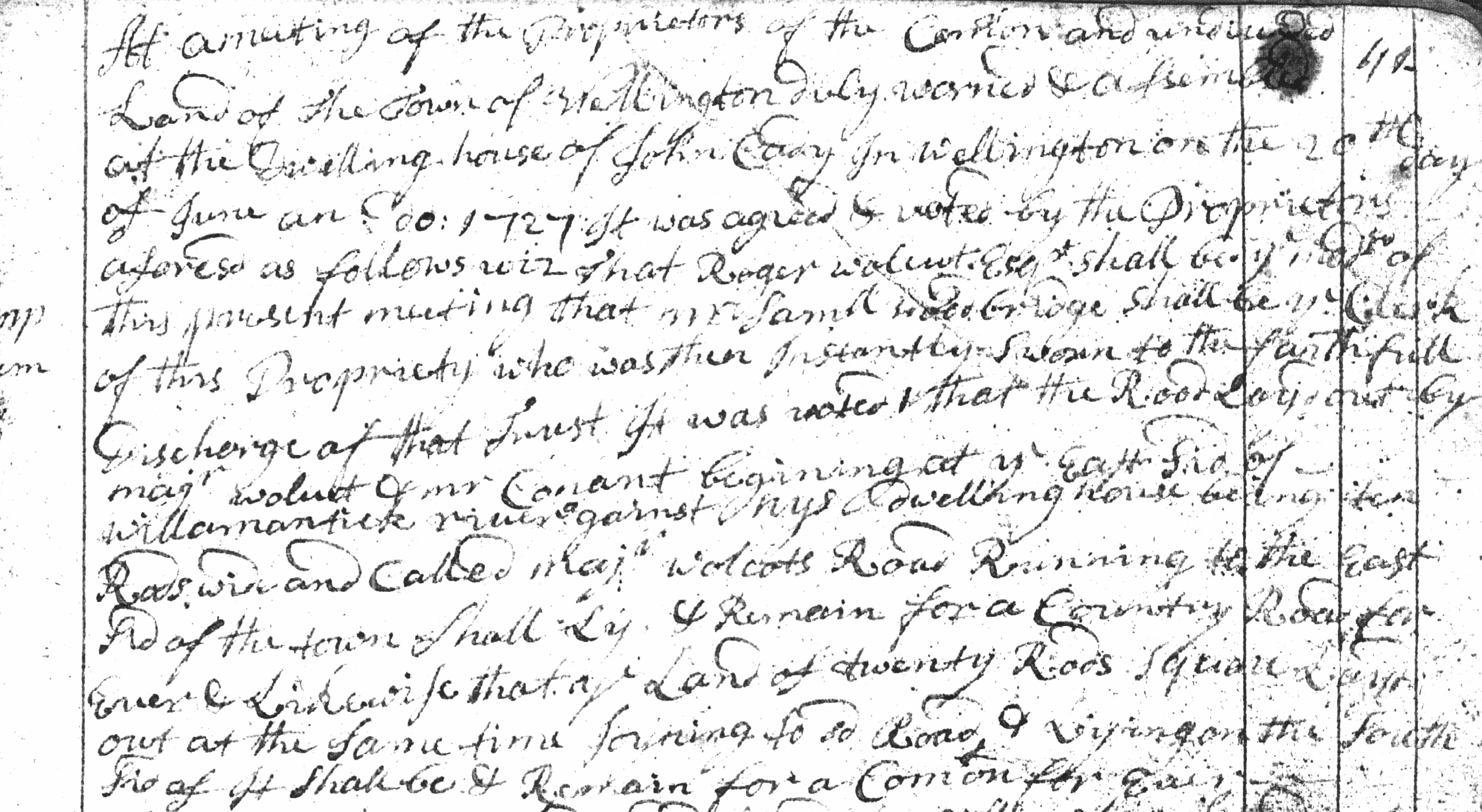
“At a meeting of the Proprietors of the comon and undivided land of the Town of Willington duly warned & assembled at the dwelling house of John Cady in Wellington on the 20th day of June an : do : 1727 it was agreed & voted by the Proprietors a fore sd as follows viz :…
…that the road layd out by Majr Wolcot & mr Conant begining at ye eas sid of willamantick river against Nys dwelling house being ten rods wide and called Majr Wolcots Road running to the east sid of the town shall ly and remain for a country road for ever & likewise that ye land of twenty rods square layd out at the same time joining to sd road & lying on the south sid of it shall be & remain for a comon for ever…
...that ye comon & undivided land in Willington layd out into eighteen lots by Majr Wolcot & Mr Conant as discribed in the platt drawn by sd Conant dated March 25 : 1726 shall be and remain eighteen lots to ye proprietors & their assigns for ever…
that thear shall be three comon ways five rods wid layd throu the town from the west to the east sid upon the dividing lines between the ranges of lots abutting one upon another to be allowed gratis one half part of each lot as far as the lott extends
and one other other common way from ye northermost of ye three common ways to ye southermost of them between the 3d and 8th lotts the 2d and 5th lotts and ye 6th and 9th lotts to be allowed gratis one half out of each of the sd lotts so far as they extend saverelly provided never the less that whear the [premises] in the lines above mentioned is not suitable for that purpose the way shall pass on ye next suitable ground & the proprietors whose land as taken thear by shall extend the lott half the weidth of the sd way into the adjoint lott that should have supplied on half of the said way and these severall ways to ly for the perpetuall convenience of ye [town]
that theare be a common way five rods wide from mansfield bounds at ye south west corner of the ceder swamp lots alying by the ceder swamp lotts and continue that corse to mr jenings lot & then alying that line round to ye lots (no 4) & along up ye line ot yt lot northerly to ye southermost of the three ways above mentioned to ly for ye town for ever”
(Willington Records, Book B, Pages 41, 42)
As noted, Josiah Conant’s plot showed the eighteen lots. The names of the Proprietors were apparently annotated on Conant’s plot on the lots assigned to each at the June 1727 meeting. The plot also showed most of the pre-existing farms and land grants with their owners names annotated.
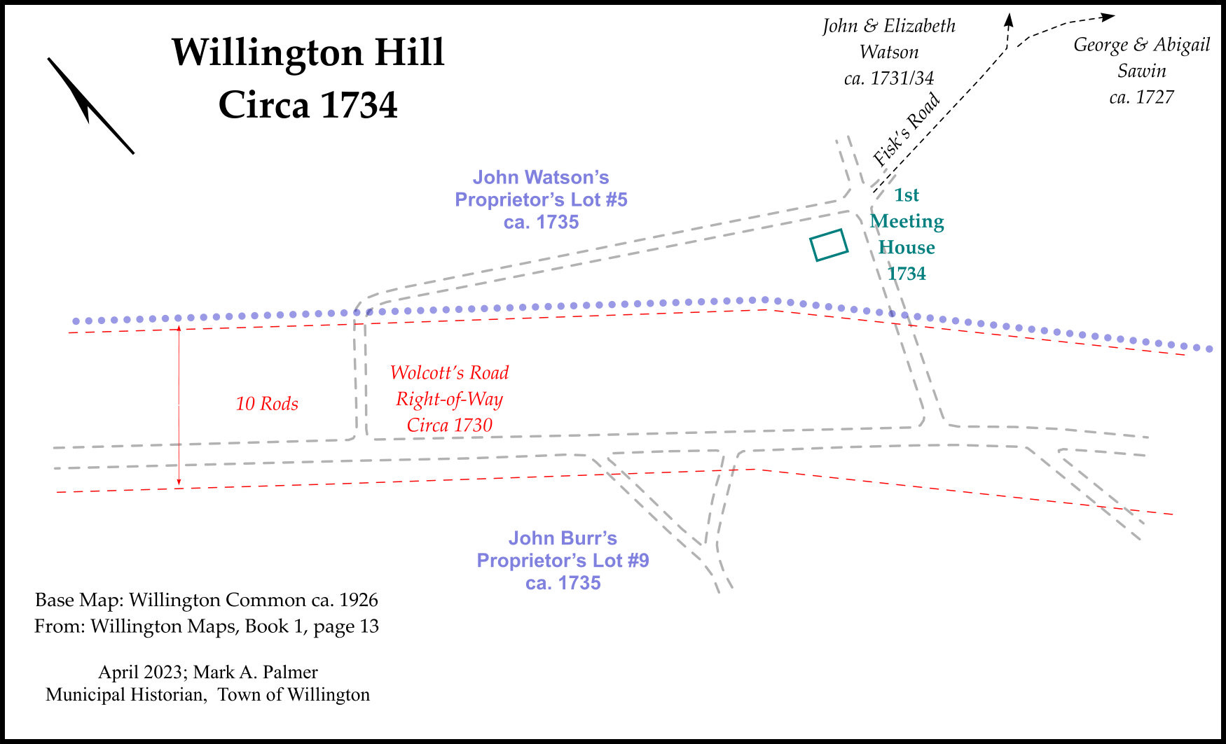
There are some details missing and apparent errors on Conant’s plot, such as the extent of Colonel Allyn’s three hundred acre grant adjacent to Moose Meadow and a missing land grant along the Willimantic River. Many of the stated boundary distances are suspect as well as they don’t match up with later deeds or present day measurements. The plot shows the principal road across town, named Major Wolcott's Road, running from the Willimantic River to the town of Ashford and the lot for the future Meeting House on Willington Hill, abutting Wolcott’s Road.
In October 1727 the General Assembly in recorded the Proprietors’ division of Willington.
October, 1727
"Be it enacted by the Governour, Council and Representatives, in General Court assembled, That the warrant calling a proprietors meeting at Wellington on the 20th day of June last, together with the division made of Wellington by the proprietors at their proprietors meeting at Wellington on June 20th and 21st, 1727, as also the map upon which the division is predicated, dated March 25th, 1727, shall by the Secretary be entered upon the Colony book of records of surveys; the charge thereof to be paid by the proprietors." (Connecticut General Assembly, The Public Records of the Colony of Connecticut, from: May, 1726 to May, 1735 Inclusive. Pages 136, 137)

Wolcott’s Road
At the June, 1727 Willington Proprietor’s meeting held at John Cady’s house in Willington:
“...it was voted 1 that the road layd out by majr Wolcot & mr Conant begining at ye eas sid of willamantick river against Nys dwelling house being ten rods wide and called Majr Wolcots Road running to the east sid of the town shall ly and remain for a country road for ever...” (Proprietor's Meeting, June 20, 21, 1727. Willington Records, Book B, Page 41)
As noted above, Wolcott's Road was declared to be a Country Road. It was one of three Common Ways across town. A Country Road or Common Way, was a road connecting towns. The term can sometimes be found mistranscribed as “County Road” leading one to assume that the road was laid out by a county entity.

The as-trod course of Wolcott’s Road was revisited in 1730. New bound marks were made or perhaps the original bound marks were renewed and the width of the right-of-way was adjusted making the original five rod width ten rods through most of the course.
The Selectmen recorded bounds and the road’s right-of-way start, length, end and width. The selectman’s record for the road was accepted by a vote at the November 25, 1730 Town Meeting.
The Town Meeting record of the course of the road with new bound descriptions starts at the bottom of page one of the first book of Town Meetings and continues on the verso.
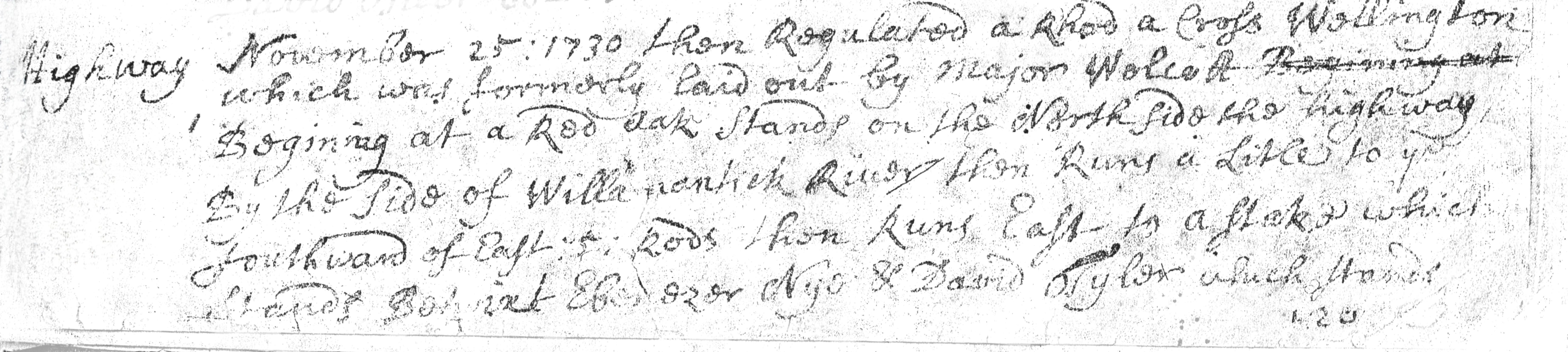
"Highway November 25 : 1730 then regulated a Rhod a cross wellington which was formerly laid out by Major Wolcott ------------------ begining at a red oak stands on the north side the highway by the side of Willimantick River then runs a litle to ye southward of east : 5 rods then runs east to a stake which stands betwixt Ebenezer Nye & David Tyler which stands 120" (ed. continues verso: "which stands a 120 Rods from the Riv [ ]") (Willington Town Meetings, Book I, Page 1)
The upper corner of the page is missing with the description of the bounds for the middle section of the course interrupted. The list of bounds picks up again on Willington Hill and continues to the pre-1727, old Ashford line, just east of the Fenton River. The western mile of Ashford was annexed to Willington.
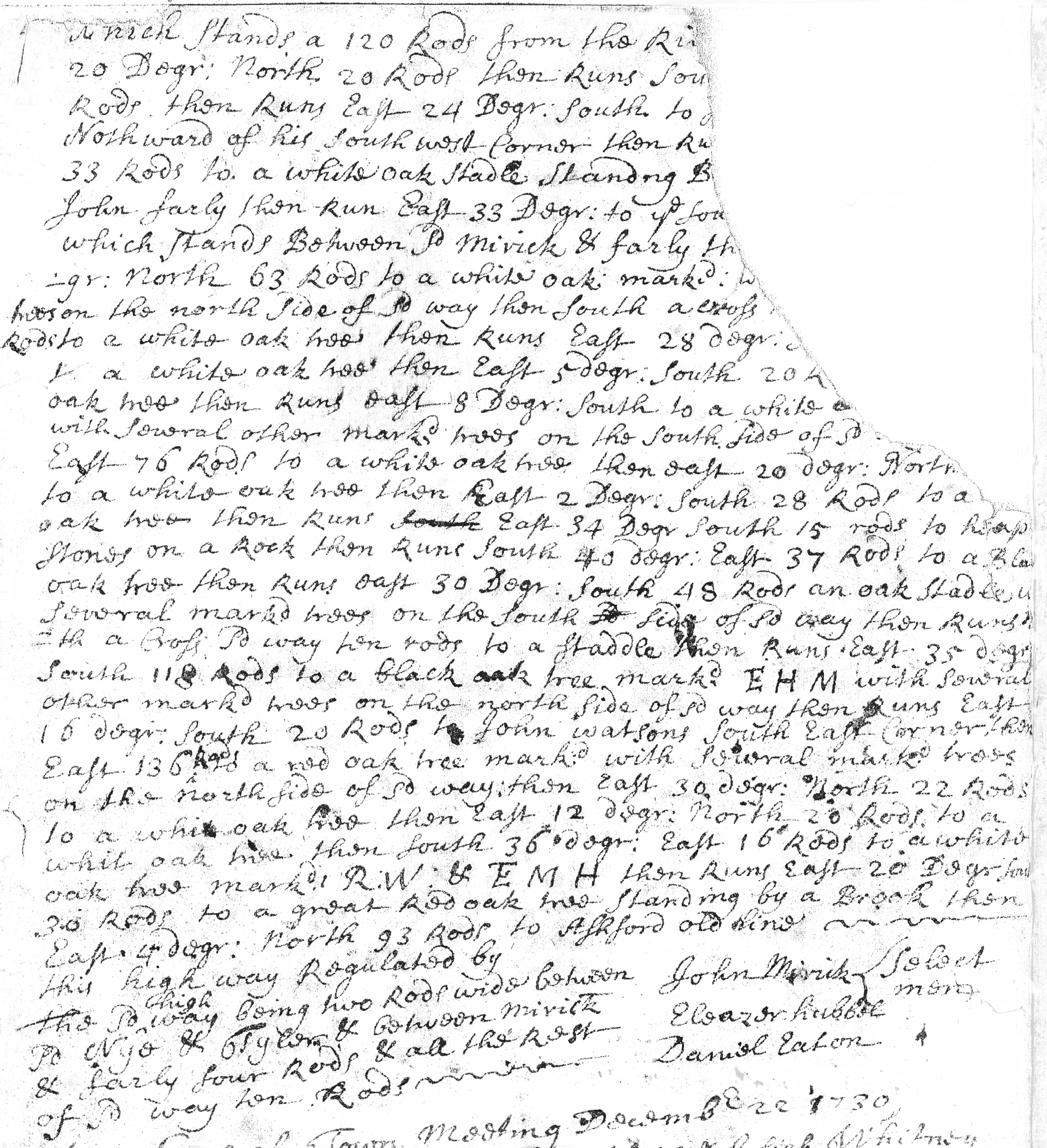
The record closes by stating the width of the road’s right-of-way.
"… The Sd high way being two Rods wide between Sd Nye & Tyler & between Mirick & Farly four Rods & all the rest of Sd way ten Rods - - - - this highway Regulated by John Mirick Eleazer hubbel Daniel Eaton } Select men" (Willington Town Meetings, Book I, Page 2)
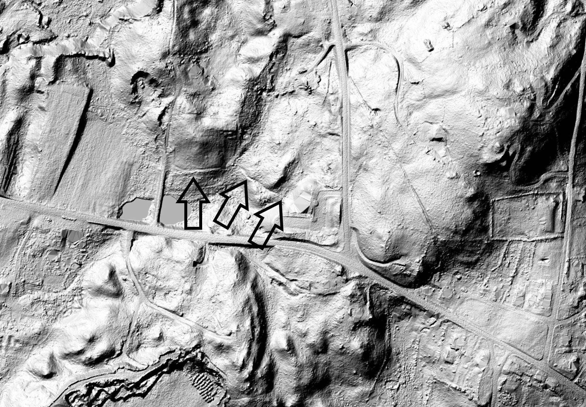
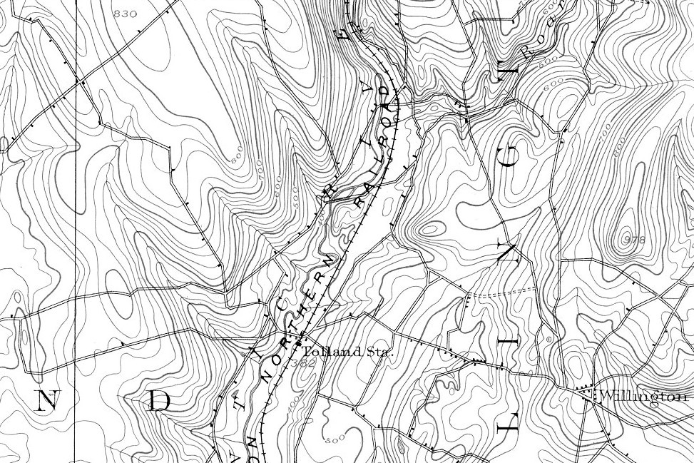
The course for the section of road east of Tyler & Nye along Merrick & Farley’s lands to Willington Hill although missing can be followed with the town's GIS using the light detection and ranging (lidar) hillshade elevation projection. Properties abutting Wolcott’s Road, using the road as a bound provide another reference. Wolcott’s Road was used as a bound dividing Proprietor’s lots with some lots on the north side and others on the south side of the road.

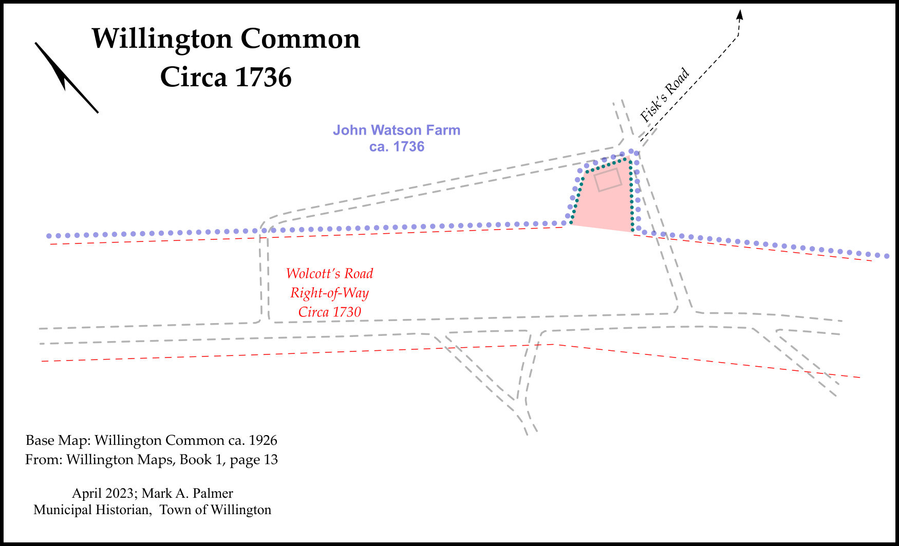
Two years after the frame of the Meeting House was erected on Willington Hill, John Watson, owner of the land, deeded a lot for the Meeting House to the town. The south bound of the lot was along the north line of Wolcott's Road and this lot was the initial part of Willington Common.
"To all people to whom these presents come Greeting know ye that I John Watson of Wellington in the County of Hartford & Coloney of Connecticut in New England for the consideration of a valuable sum of Lawful Current money received to my full satisfaction of the Select Men of Wellington in the County & Coloney afore sd do give grant bargain sell & confirm unto the said Select Men & to their succesors & the town of Willington for ever a certain tract or parsel of land scituate lying & being in the township of Wellington afore sd that is to say twenty rods bounded as followeth viz begining at a black oak staddle standing at ye north east corner of ye Meeting House thence runing west three rods to a black oak staddle standing at ye north west corner of ye Meeting House thence runs bearing to ye south west four rods to a black oak staddle standing in or near Majr Wolcots Road thence runs easterly five rods to a heap of stones thence northwesterly five rods to the first mentioned bounds sd land being bounded south on Major Wolcots Road or otherwise ye Country Road & on all other parts on said Watsons land to have & to hold the above granted & bargained premises with ye appertunances unto the said town of Wellington & to their heirs & assigns for ever to theirs & there own proper use & behoof
...where of I have hereto set my hand & seal the nineteenth day of April in the ninth year of the reign of our soverign lord George the Second of Great Britain &c King Annoyue Dommie 1736 John Watson
A true coppy of a deed I recd for record September ye 25th 1749 Test Stephen Fisk Town Clerk" (Willington Records, Book C Pages 191, 192)
Using a variety of existing town records, such as the 1730 Town Meeting description, with some allowance for inconsistencies between the records, such as distances and widths, it’s possible to fill in most of the blanks of the course of Wolcott’s Road across town. The majority of the physical as-trod course can be plotted with some certainty, as seen in the lidar image below.
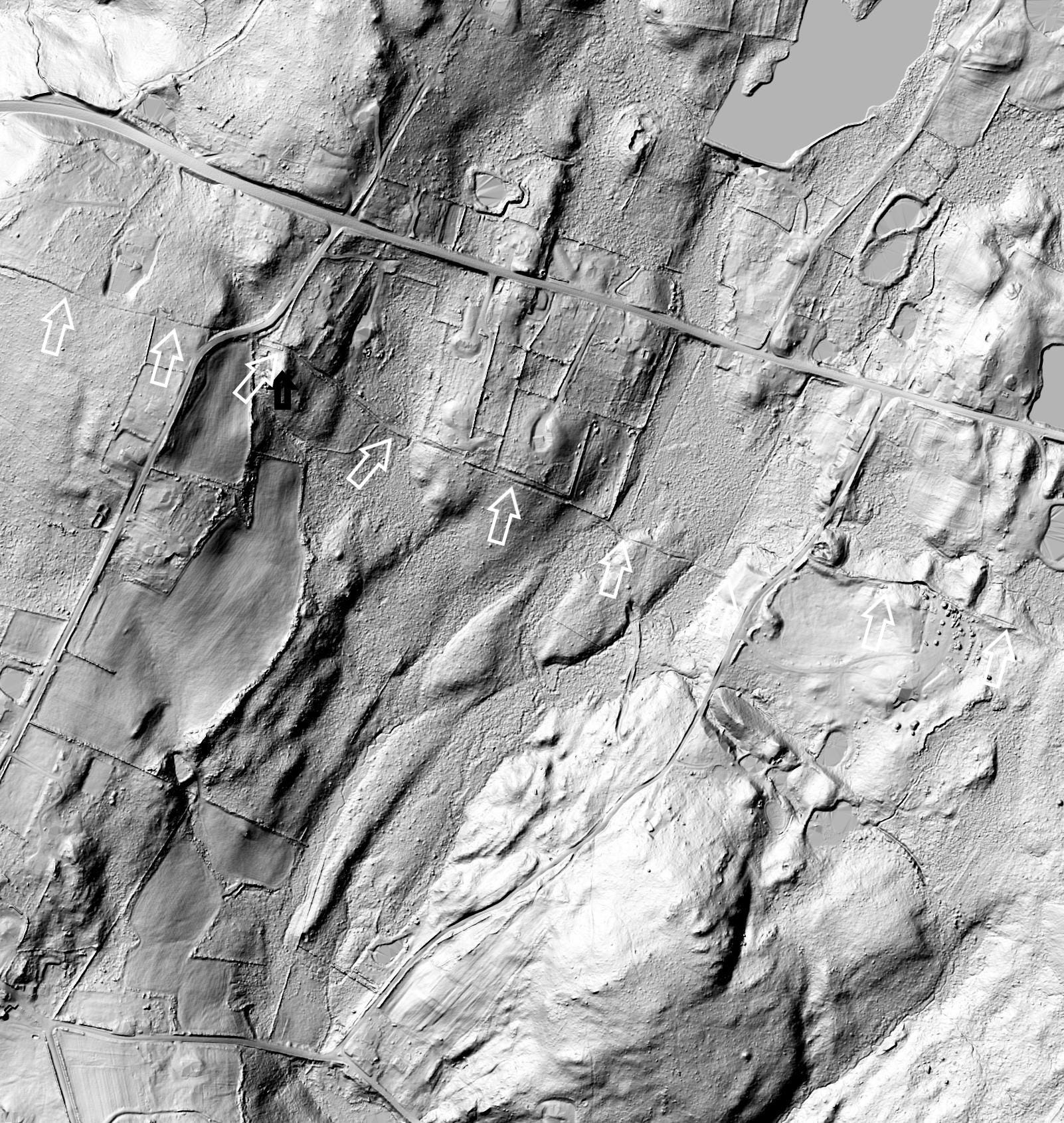
Several sections of the course of Wolcott’s Road still run as the road was drawn in 1726 and revisited in 1730, even though the course was altered in the 1800s Turnpike era when the Tolland County Turnpike came through. There were also alterations with the creation of the State’s Trunk Road network in the early 1900s. The trunk road route becoming Connecticut Route 44, redesignated now as Route 74.
The ten rod width of the right-of-way across the top of Willington Hill helped define a site for the location of the Meeting House and it’s lot and to later define the bounds of Willington Common.

Water’s Edge, Ebenezer Nye.
I’ve looked for information about, discussions of, reasons explaining or any rational behind why fords were sited where they are, and have come up short, so far. Why was a ford sited at a particular place? What is it about the flow of water at a site that makes crossing it here better/easier than crossing somewhere up or downstream. And somewhat tangential, which came first, the ford or the path to and from it?
Bridge placements on the other hand tended to places where the abutments would be raised over the water enough to deal with normal seasonal flooding. Some road descriptions, charting the course laid out to a stream or river crossing note that a bridge can cross the water at the best site (for the abutments), rather than the existing fording place.
One aspect to colonial era cross-country travel, on foot, horseback or by cart, seems to have been predicated on having numerous options, a need for a variety of routes and river crossings. From suggestions provided by the paths the English assimilated, the pre-colonial network of paths appears to have offered different routes or travel options connecting communities and providing access to the country.
For crossing the Willimantic River, along the Willington and Tolland town line there were at least four colonial era crossing places on the Willimantic River in this general area, at least from primary sources seen to date.
The southernmost crossing place, upstream of Conant Brook, is described as the canoe place, there are path remnants pointing to it on the Willington side. Upstream are three places where paths crossed the river. The northernmost is where a stream joins, the next below is where the river widens and the place near Ebenezer Nye’s dwelling is where the river becomes constrained by an elevated part of the floodplain.
Near the site of Ebenezer Nye’s Willington dwelling, upstream from the present day Route 74 bridge, there is a cut in the riverbank that descends to the water’s edge that would make for a easy grade down to the water for a ford. This cut aligns somewhat with the path description in some deeds.
Ebenezer Nye was a legal Inhabitant of the Town of Tolland. He owned land on both sides of the Willimantic River and he was apparently living on the Willington side of the river in 1730. He was in the company of several other Tolland men living or owning land on the east bank of the Willimantic River, such as John Cady, Joseph Hatch, Ichabod Hinkley and Daniel Eaton.
The Town of Willington paid Ebenezer Nye three pounds in New England script (“currant money”) for land taken for Wolcott’s Road. The beginning of the road apparently went through Nye’s land at this time. The road later relocated to the boundary between Nye and David Tyler, or the road became the bound. Maps identifying the 1930s right-of-way for the Wilber Cross Parkway through town are sometimes referred to as “taking maps.”
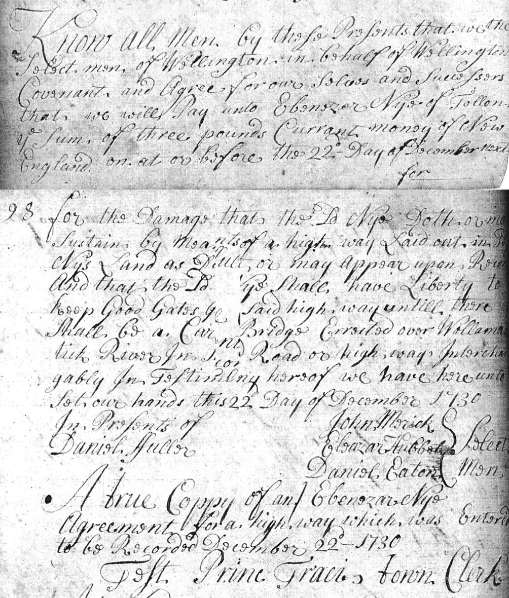
“Know all men by these presents that we the Select men of Wellington in behalf of Wellington covenant and agree for our selves and successers that we will pay unto Ebenezer Nye of Tollon ye sum of three pounds currant money of New England on at or before the 22d day of December next for the damage that the sd Nye doth or may sustain by means of a high way laid out in sd Nys land as doth or may appear upon recor[d] and that the sd [N]ye shall have liberty to keep good gates [ ] said high way until there shall be a car[t] bridge errected over Wollamantick river in [sd] road or high ways interchagably in testimony hereof we have here unto set our hands this 22d day of December 1730 In presents of Daniel Fuller John Merick Eleazar Hubbel Daniel Eaton } Select Men A true coppy of an Ebenezar Nye agreement for a high way which was entered to be recorded December 22d – 1730 Test Princ Traci Town Clerk" (Willington Records, Book A, Pages 97, 98)
As the record notes, Mr. Nye was given liberty to close the road with gates, possibly at or near the ford-way, as part of his land was fenced in. This allowance in place until a cart bridge was built over the Willimantic River. A deed from the early 1750s, mentions a cart bridge across the Willimantic River. Unfortunately Town Meeting records from 1740 to 1760 are missing so there is no record of a Town Meeting vote to build the bridge, however town land records provide some clues.
The start of the course of Wolcott’s Road is described in the following 1759 deed by Ebenezer Nye to his son Benjamin for fifty acres on the east side of the Willimantic River in Willington. It uses Wolcott's Road as the south bound of the lot. The bound description shows the way running east from the river, complete with a notation of where the way branches (present day Phelps Way). The deed notes the bridge across the river and mentions a beaver dam on the Willimantic River.
"Know all men by these presents that I Ebenezer Nye of Tollon in the county of Hartford & Collony of Connecticut in New England for and in consideration of the real and entier love good will and effection which I have and do bear towards my son Benjamin Nye of Wellington in County and Colony a fore sd have therefore and by these presents freely fully and absolutely give grant alien convey and confirm unto him the sd Benjamin Nye his heirs and assigns for ever one piece or parcell of land scituate lying and being in the township of Wellington afore sd containing fifty acres and is bounded as foloweth (viz) begining at a red oak tree marked by the bridge that crosses Willamantick River then runing easterly as the high way now goes to a stake and heap of stones near the turn of the road that turns south east thence runing northerly to an oake staddle marked with stones about it then westerly to a hemlock tree marked near the bank of Willamantick River thence southerly as the revir runs to the beaver dam then southerly as the fence now stands to the high way near the bridg southerly on the high way easterly on Robert Parker northerly on Isaac Hubbard westerly on the river and my own land... In witness where of I have hereunto set my hand seal this 1[5]th day of May AD 1759" (Willington Records, Book C, Pages 402, 403)
On December 2, 1788, Benjamin Nye, living in Willington on the above fifty acres, deeded part of his farm to his then father-in-law Joseph Crocker. The bounds begin near Nye’s bridge where the raised floodplain funnels the river. The bounds proceed along the north line of Wolcott's Road, providing a more detailed description of the course. Distances between boundary markers along Nye's land are noted. The deed also mentions the old beaver dam. That the beavers made a dam on the Willimantic in this area is probably a clue about why the place was a good spot for a ford.
December 2, 1788 "Know ye that I Benjamin Nye of Willington in Tolland County for the consideration of one hundred pounds lawful money full satisfaction of Joseph Crocker of said Willington do give... two certain pieces of land... containing thirty four acres... the first begining at a large black oak tree standing N. E. of Nyes bridg so-called on the east bank of Willimantick River being the S:W corner of my home farm thence E: 5° S: 32 rods to a stake and stones from thence E: 24° S: 13 rods to a stake and stones thence E: 26° N: 20 rods to a stake and stones thence E: 14° N: 14 1/2 rods to a stake and stones..." Willington Records, Book F, Page 141
On December 6, 1788, Joseph Crocker deeded the above land to his daughter Mary Nye, wife of Benjamin. It would appear that Joseph Crocker bought the land with the intention of giving it to his daughter, perhaps ensuring that she retained something of Benjamin’s estate should he pass away intestate with his estate divided between the children from his previous marriage. This act would also assure that Mary’s children by Benjamin would have her estate when she passed away. Sometimes these seemingly extraneous details found in old land records provide a view of family and societal relationships not seen in other writings.
From the records seen to date, the course of Wolcott’s Road through Willington, going back to 1726, can be plotted with some certitude. Whether the entire course was comprised of assimilated ancient footpaths may be conjecture, however the major sections can be identified as such from descriptions in the earliest records combined with the signatures of the paths that crossed or intersected Wolcott’s Road.

A Tolland connection
With Wolcott’s Road designated as a Country Road, one question might be did it connect to a Country Road in Tolland? Given the start of the settlement of Tolland some five years prior to the 1720 Willington Patent and Ashford opened for settlement in 1706, Wolcott’s Road makes an obvious choice of a route connecting those two towns.
For the Tolland connection one clue comes from Ebenezer Nye again. In 1749, Nye was living on the west side of the Willimantic River in Tolland. Nye’s home lot in Tolland was apparently laid out for him in 1722 and over the years he bought abutting lots and ended up owning land downstream of the ford.
In 1749 Ebenezer Nye deeded a strip of land running northerly from a new bridge over the Willimantic River through his land. The strip of land connected with a road past his dwelling.
June 20, 1749
"Know all men by these presents that I Ebenezer Nye of Tolland in ye county of Hartford and colony of Connecticut in New England for ye consideration of seven pounds money to me paid by ye Town of Tolland have therefore and do by these presents give grant bargen sell and convey unto Deacn John Tyler & Joshua Wills Selectmen of the Town of Tolland and so to ye rest of ye Inhabitants of Tolland and their successors forever one certain peice of land in Tolland afors sd for ye use of a highway which land is two rods in wedth & forty two rods in length bounded as to say begining at Willamantick River about six foot south of ye new bridge a little below my house & to extend north ye said two rods in width & from thence run northwest six rods & thence north six degrees west nine rods & from thence west 27 degrees north twenty seven rods to ye highway by my house..." (Tolland Records, Book 4, page 526)
Unfortunately the description of the course of this road doesn’t align with present day roads or roads shown on 1800s town, county or USGS maps except for a short stretch of the road through the Nye Holman State Forest. There is no indication in lidar imaging of a track running north and to the northwest as described in the deed. So, the deed seems to show only the intent to connect the new bridge to a primary road northerly of the bridge. The primary road Nye’s road would connect to would be the old Hartford Road.
In essence, from the description in Ebenezer Nye’s 1749 deed, Wolcott’s Road would appear to connect to the old Hartford Road in Tolland, the Country Road from Woodstock through Ashford, Willington and Tolland that is noted on John Chandler’s 1705 Map of the Mohegan Sachem’s Hereditary Country.
Continued with Part IV
Mark A. Palmer
Municipal Historian, Town of Willington
Shetucket Country, Eastern Algonquia
Excepting all materials in the public domain or provided under a Creative Commons Public License; Original content © 2025, all rights reserved.
References:
The Public Records of the Colony of Connecticut, From May, 1717, to October, 1725. Charles J. Hoadley. Hartford 1872.
Land Grant, May 1719, Page 113:
"Forasmuch as this Assembly, at their sessions holden at Hartford May 13th, 1686, granted to Mr. Symon Wolcott, late of Windsor, deceased, two hundred acres of land, which was surveyed to the heirs of the said grantee by Mr. Kimberly, surveyor of land, upon the land on the mountains eastward of Hartford ; and Roger Wolcott, one of the heirs of the said grantee, purchased the said lands of the rest of the heirs, as appears by their deed lawfully executed, dated September 14th, 1714 ; and since it has been found that the said survey was disallowed by the committee appointed by this court to settle the lands on said mountains : This Assembly do appoint and impower Lt. Col° Mathew Allyn to survey and lay out to the said Roger Wolcott the said grant of two hundred acres in the ungranted lands of this Colony, for the sure holding of it to him and his heirs forever, according to the true intent of said grant and purchase."
Willington Patent, May 1720, Page 194:
"This Assembly do hereby give, grant, bargain, sell and con- firm, unto Roger Wolcott Esqr of Windsor, Major John Burr of Fairfield, John Riggs of Derby, Samuel Gunn and George Clark the third of that name, both of Milford, John Stone of Stanford, Ebenezar Fitch of Windsor aforesaid, and Peter Pratt of Hartford, being all of this Colony, one certain piece or parcel of land, bounded south on Mansfield bounds as stated in the patent to that town dated October the 20th 1703, west upon Willamantick River, north upon Stafford, east upon Ashford, by a line drawn from Ashford nine mile and half tree standing in Mansfield line southerly of a house set up by Obadiah Abbey, then to run from that tree north nine degrees easterly to Stafford bounds ; the whole parcel being in estimation about sixteen thousand acres, be it more or less, it being in consideration of the sum of five hundred and ten pounds in current money by instruments well executed in the law secured to be paid to the publick treasury of this Colony by said grantees : To have and to hold the same to them, in equal parts or proportions, saving all grants by this Assembly already made of said lands and regularly laid out and returned. And this Assembly do hereby further order and enact, that a patent, at the request of the said grantees, under the seal of this Colony, signed by the Governour and Secretary, be made of the aforesaid land, to the said Roger Wolcott, John Burr, John Riggs, Samuel Gunn, George Clark, John Stone, Ebenezar Fitch, and Peter Pratt, for the firm holding the premises to them and their heirs forever."
Roger Wolcott:
Assistant; auditor; Justice of the Peace for Hartford County; Speaker of the Lower House of Representatives; Governor of Connecticut Colony from 1751 to 1754
General Assembly Delegate (various dates):
Roger Wolcott, Ebenezer Fitch, Windsor
Major John Burr, Fairfield
John Riggs, Derby
Samuel Gunn, George Clark, Milford
John Stone, Stanford
Peter Pratt, of Hartford, attorney
John Reed, of Boston, attorney
The Public Records of the Colony of Connecticut, From May 1726 to May 1735 Inclusive. Charles J. Hoadly, Hartford 1873
The Mile of Ashford annexed to Willington, October 1727, Page 144:
"The inhabitants on the west side of Ashford having prayed this Assembly that they may be annexed to the town of Wellington, upon which the agent of Ashford declared his free consent that one mile of said Ashford, to run cross said town on the west side thereof, should be annexed
to Wellington aforesaid, the which the agent for said inhabitants freely accepted, and both said agents accordingly agreed before this Assembly: Whereupon it is enacted and declared, that one mile in breadth, to run cross on the west side of said Ashford, shall be annexed to the town of Wellington aforesaid, so far as it relateth to parish charges, and the same is accordingly annexed to said Wellington, and the inhabitants living on said mile are discharged from all parish charges in Ashford afore said."
Tolland, Town of, Records as noted.
Willington, Town of, Records, as noted.